Home> River Research> Pittsburgh Pool> Biotic Assessment
Biotic Assessment
Sue Thompson PhD. 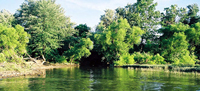
The goal of the 3R2N project is to promote understanding of preservation and restoration of green infrastructure in the Three Rivers area. By accurately identifying and understanding the distribution and abundance of plant species along our rivers, planners and citizens will be better informed to discuss opportunities for restoration and implement ecologically informed riverbank management.This assessment summary compliments the 2000 Riverbank Conditions Report and addresses woody plant biodiversity along riverbanks in the Pittsburgh Pool. This assessment establishes baseline data for defining the quality and types of habitats present by looking at streambank woody vegetation and mapping their distribution in the region.
Biodiversity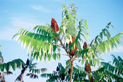
Biodiversity describes the wealth and variety of plants, animals, and microorganisms found in an area. The first step in understanding the biodiversity of an area is to identify the species found there. Since groups of woody species are used by ecologists to define terrestrial habitat types, we have focused our data collection on the identification and association of woody species along the rivers. Individual woody species can be used as indicators of habitat quality (soil types, disturbance level, soil moisture, etc.). Groups of plant species found in association with one another indicate specific habitat types. In addition to the identification of all woody vegetation, we make special note of all non-native plant species, woody or herbaceous. The presence of non-native plants can be an indication of changes in the ecological conditions of an area -- including repeated habitat disturbance, changes in habitat conditions, or local loss of native species. Some of the non-native plants present along our riverbanks have become invasive and are considered undesirable for these reasons. (Examples of these invasive plants include Japanese knotweed and purple loosestrife.) Some of the most important issues in urban biodiversity -- habitat restoration and development -- relate to the control of introduced species, particularly those that are becoming invasive species. Understanding the relative distribution and abundance of native and introduced species will be of vital importance for preserving local biodiversity as riverbank development continues.
Distribution and Abundance
Species identity, distribution and abundance will allow us to determine the frequency of habitats along the rivers. A long-term goal of our project is the production of a database, allowing us to map the distribution of habitat types along the rivers. To date we have identified 76 species of woody plants along the riverbanks. Of these 76 species, 13 were very common and found in all of the 2000 survey areas. The native tree, Sycamore (Platanus occidentalis) is the most frequent woody plant growing along the rivers in the Pittsburgh Pool. The introduced Tree of Heaven (Ailanthus altissima) is the second most abundant woody plant.Although the data in our assessment are not yet correlated with other contemporary or historical data, this study is significant in that it establishes an accurate baseline to compare with future data and historical information. Some of the significant findings that came out of our study establish the relative frequency and abundance of native and introduced plants in the Pittsburgh Pool:
- Brunot Island has the highest average vegetation cover composed of woody plants, followed by the left bank of the Ohio River. For all other river areas measured in 2000, the percentage of woody plants is approximately equivalent.
- The percentage of introduced species averages 36% across all riverbanks in the Pittsburgh Pool.< Herr’s Island has the highest average abundance of introduced species (55%). The Ohio River has the highest average incidence of introduced plants relative to the Allegheny or Monogahela Rivers.
- Islands in the Allegheny River display both the highest and lowest averages of introduced plants (Herrs Island at 55% and Six Mile Island at 20%).
Continuity and Canopy
We collected data on continuity of vegetation and the height of woody plant canopy to help us estimate the age, extent and quality of different habitat types. Our vegetation continuity types range from areas with no woody vegetation to areas of woody vegetation both continuous and dense like a forest. Canopy height measured in 2000 ranged from 0-34 meters above the ground.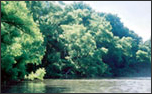
- 2.6% of the area surveyed along both banks of the Allegheny River, the Monongahela and Ohio had no vegetation.
- Conversely, 40.9% of the areas surveyed had a 75% or better coverage of continuous and dense vegetation.
- Six Mile Island has the tallest average canopy height of any area we sampled in 2000.
- The most mature forests in the Pittsburgh Pool are along the Allegheny River where woody vegetation is the tallest.
- The shortest canopy heights are found on Brunot Island and on the banks of the Ohio. This is also where Japanese knotweed is the most abundant species.
Over 88% of the riverbanks in the Pittsburgh Pool are currently not managed. Incorporating a broader representation of citizenry into planning discussions will be of paramount importance in the near future.
