

Home> River Research>History> Engineering Pittsburgh's Three Rivers
History From Rivers to Lakes: Engineering Pittsburgh's Three Rivers
Shera Moxley, Ph.D. Candidate,
Department of History, Carnegie Mellon
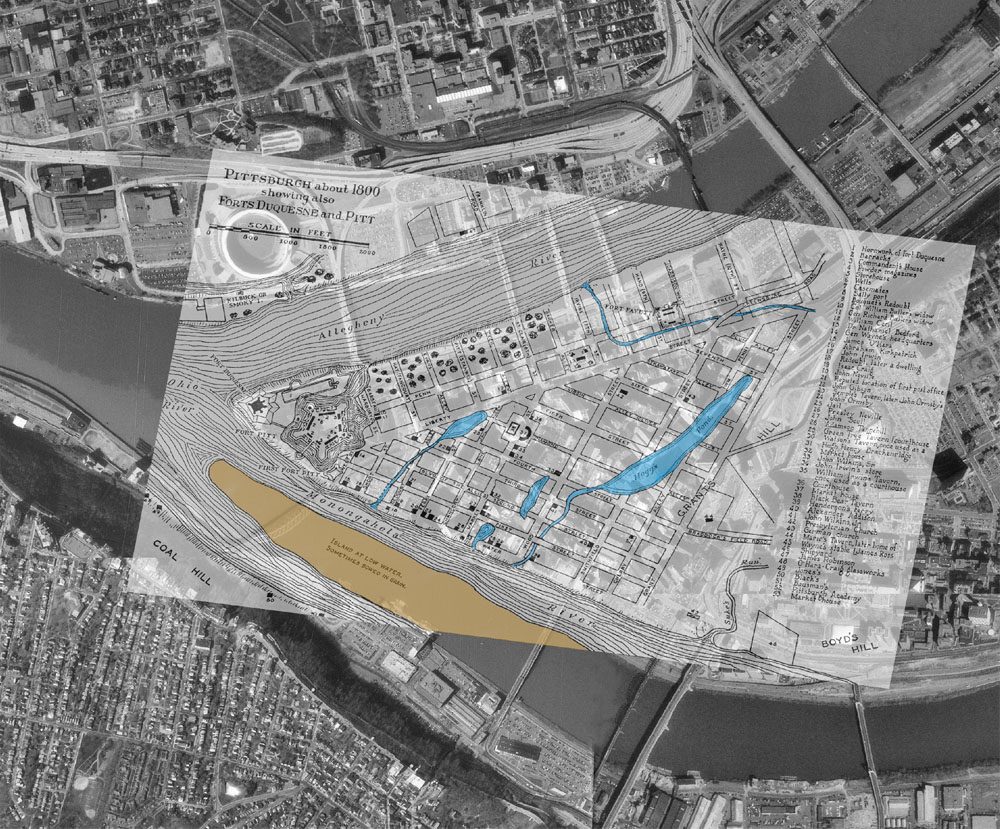
From first contact nearly three centuries ago, European explorers of the trans- Appalachian West recognized the strategic and commercial value of the Allegheny, Monongahela, and Ohio rivers. They vied for control over the city of Pittsburgh sited at the confluence of these vital water highways. Immediately they prioritized the economic potential of the rivers and sought to tame them for economic ends. They worked to improve navigation of the three rivers--to simplify, manipulate, and thus control the rivers' natural hydrologic systems--to facilitate commercial gain. This report discusses the evolving technologies various interests employed to transform Pittsburgh's three rivers from hazardous, unpredictable natural streams into controlled interstate water expressways.
The history of engineering Pittsburgh's three rivers may be divided into four technological stages. The first spans colonial exploration and state efforts in the early republic until 1824. During this time, French, British, and American explorers mapped the Allegheny, Monongahela, and Ohio rivers as well as their tributary streams and the watersheds they drained. Once they obtained basic topographic and hydrologic data, they attempted to improve the navigability of these streams to win for Pittsburgh the role of commercial gateway linking the trans-Allegheny western hinterlands with Atlantic port cities. Colonial and state governments designated Pittsburgh's rivers navigable public highways and prohibited their obstruction by artificial structures. Both private and public interests supported an assortment of efforts aimed at improving the rivers' channels, including removing snags, scouring sand and gravel bars, and exploding boulders and root clusters. These efforts required extensive annual maintenance, however, and made no permanent improvements to the navigability of the rivers.
The second period of river engineering marked the beginning of federal participation in waterway improvement, carried out under the auspices of the Army Corps of Engineers. In 1824 Congress passed the first law giving the Army engineers authority to improve navigability on the nation's inland rivers. For the next half century the Corps of Engineers persevered through acrimonious sectional debate over federal involvement in civil works projects, intermittent congressional funding, and the disruptions of war to effect open-channel improvements on the Ohio River. Like their predecessors, Army engineers pursued comprehensive channel clearance work to remove obstructions to navigation. They experimented with a variety of wing dams to deepen channels and lengthen the navigation season for lighter-draft vessels. But Army engineers were not the only ones active in improving navigation on Pittsburgh's rivers. During this period the state of Pennsylvania pursued similar efforts on the Allegheny River. Private parties attempted more comprehensive structural engineering on the Monongahela River. The Monongahela Navigation Company worked to control that river through a system of dams with toll locks, providing a slackwater system navigable year-round.
After the Civil War it became evident to federal planners that even the thirty-inch channel achieved on the Ohio River was inadequate for the dramatically increasing commercial tonnage on Pittsburgh's rivers. From 1874 to 1929 the Corps of Engineers emplaced a system of dams with locks on the Ohio River from Pittsburgh to its junction with the Mississippi River at Cairo, Illinois. Canalization of the Ohio River guaranteed a nine-foot navigation channel year-round, independent of the vagaries of seasonal and meteorological flow fluctuations. With the successful construction of the slackwater system, the corps accomplished complete and permanent control of the Ohio River. In addition, it canalized the Allegheny River and purchased the Monongahela slackwater system from its private owners, restoring toll-free navigation to Pittsburgh's most commercial river. By the onset of the Great Depression, the Allegheny, the Monongahela, and the Ohio had been transformed from naturally flowing rivers into restrained stairstepped chains of lakes.
In the most recent period of the history of engineering Pittsburgh's three rivers, the Corps of Engineers modernized its slackwater systems to speed commercial navigation. The corps replaced first-generation dams on the Ohio River with concrete high-lift dams to reduce the number of lockage delays. During this period Army engineers also replaced and remodeled aging structures of the Monongahela slackwater system, one of the oldest in the country. The Allegheny River slackwater system is the youngest serving Pittsburgh and carries the least commercial tonnage of the three. It has not yet required extensive modernization, but many of its original structures are nearing the end of their projected service lives. An opportunity may exist here to reconsider the commercial utility of a controlled navigation system.
Over the course of nearly three centuries, then, various private and public interests, dominated by the Army Corps of Engineers, have progressively altered the Allegheny, Monongahela, and Ohio rivers. These engineering efforts aimed at mitigating the unpredictable, hazardous, and costly characteristics of the rivers, transforming them into controlled chains of lakes to facilitate inexpensive commercial traffic. Today Pittsburgh's three rivers function in the landscape of the built environment more than they resemble their original natural hydrologic systems.
