Home> River Research> Allegheny River> Geology
Riverbank Geology
Roman G. Kyshakevych, Ph.D. | Henry S. Prellwitz, Ph.D.
The data from each 1/10th mile section of Pools 1, 2, 3, and 4 of the Allegheny River was entered into a computer database, to be used in conjunction with the GIS and ARCINFO mapping programs. The three major areas of inquiry using the geological dataset and the computer mapping programs are: 1) Describing which sections of the riverbank have easy, moderate, and no access, 2) Determining which riverbank sections are the best preserved, or which are closest to “pristine” condition, with minimum anthropogenic influence, 3) Using datasets generated from sections one and two to find riverbank sections that are worthy of restoration and/or other improvements
Access:
Three different grades of river access were generated : easy, moderate, and difficult/vertical access. Several variables were used to determine these access categories; the amount of restrictive vegetation, bank height and steepness, the width of the berm, if present, and the competence of the berm or bank material where one actually steps from the boat onto the shore.
Preservation:
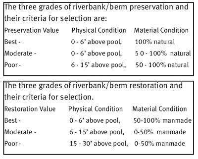
Three different grades of riverbank preservation were created, with the idea of determining which sections were best preserved in their natural state. To determine which areas qualify as best preserved, the height and frequency of flooding along the Allegheny River has to be taken into account. Another criteria used to determine preservation is the amount of manmade material present. If there is a smaller manmade material percentage in the bank or berm makeup, this can be interpreted as a more natural state.
Restoration:
The restoration potential is contingent on bank height (and potential floodplain effect) as well as soil composition. As depicted in the table below, restoration values have been identified by physical condition in relationship to the material condition of the banks. You will find maps in the reports that indicate the locations that are best suited for access, preservation and restoration.
Riverbank Grain Size and Material Type Trends
Grain size attributes are important descriptive properties of riverbanks. In general, there is a trend of coarser grains along the upstream direction. This is true for most rivers and streams, especially if material was added to the system, as seen in the Allegheny River, resulting from glacial outwash deposit erosion and transportation. Pool 1 has 78% mud, Pool 2, 48%, Pool 3, 47%, and Pool 4 at only 24%. The amount of sand increases upstream, and the cobble/gravel amounts increase upstream, except for Pool 3. This is due to a smaller number of islands, as most of the cobble and gravel sized material is exposed along island shores. The amount of rubble and fill is fairly consistent over the study area, except in Pool 1, where there was a greater amount of fill dumped over time to increase land area in and near the City of Pittsburgh. A general decrease of man-made bank materials can be traced along the upstream direction. Pool 4 reverses the trend somewhat, again due to steelmaking activity there.
Comparison: Allegheny and Monongahela Rivers
Using the material and grain size charts from the previous year’s study, differences between the Allegheny and Monongahela Rivers can be illustrated. There is a greater concentration of man-made materials (73% man-made and 27% natural) in the Monongahela’s banks compared with the Allegheny River (55% man-made, 45% natural). Another major difference in natural materials between the Allegheny and Monongahela Rivers is the amount of material in each river valley, usually referred to as the sediment load. The Allegheny River has a slightly steeper gradient than the Monongahela, but the sediment load is much greater from the influx of glacial alluvium. The load is greater than the river can easily carry and island formation results. The composition and the amount of natural materials are different between the Allegheny and Monongahela Rivers; this is why one sees no large islands or gravel banks in the Monongahela River.
