Home> Rivers Re-Valued> Urban Stream Impact Protocol
Urban Stream Impact Protocol: Allegheny County
A GIS-Based Methodology for Assessing Water Quality and Source Determination
Tal Ilany
Andrew Lee
Jon Toonkel
(2003)
The Urban Stream Impact Protocol emerges from a systematic spatial analysis of the fifty six streams of Allegheny County, PA. The Authors first developed the idea while students at Carnegie Mellon University, and finalized the Protocol as part of 3 Rivers 2nd Nature, a research project through the STUDIO for Creative Inquiry. Five watersheds were investigated over a nine-month period working under 3R2N Project Director, Tim Collins and Environmental Scientist Kathy Knauer. This Protocol is a GIS-based methodology intended to give citizens the resources and information to assess the water and environmental quality of their own surroundings. The region not only lacks data, it also lacks a standard procedure and database to assist non-scientists in their own efforts to evaluate the condition and health of the streams and rivers around them. This protocol introduces a straightforward framework for water quality testing, which can be implemented by individuals with varied scientific experience.
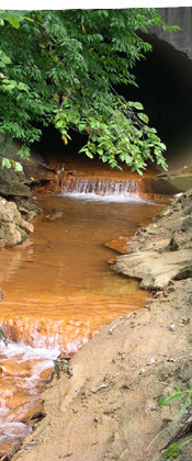
Waterways form a critical basis for regional identity and can be shaped by the land use and development in the area. The health of a stream or river correlates directly to human impacts and stresses applied to the region. Many people do not feel ownership or affinity to the watershed in which they live and might not have access to specific information that would shed light on the environmental state of their surroundings. Waterways provide recreation, beautiful scenery, and drinking water, therefore the health and quality of that water is vital to the health and safety of every person in every watershed. The GIS-based Urban Stream Impact Protocol provides citizens with the tools they need to safely learn more about the water quality in their area in order to better understand the role water might play in their life. Ultimately, this tool should be helpful in changing the way in which water is understood, managed, and used.
Surface water quality testing has typically been undertaken by professional regulatory agencies at the local and state level, supported primarily by public funds. Only in the last decade have citizens begun to involve themselves in surface water quality analysis. While this rise in citizen participation is encouraging there are still many barriers, such as the scale and cost of monitoring that make the data collection process more difficult for interested individuals and community groups without many resources. The GIS-based Urban Stream Impact Protocol
is designed to further the potential of citizen involvement by providing techniques that cater specifically to people with varying experience and different amounts of funding.
Citizen monitoring projects can redefine human relationships to streams and waterways that have long suffered without interest or care. Testing of regional surface waters is expensive and time consuming for regulatory agencies, so citizen involvement may be the only way to enable comprehensive studies. Within Allegheny County alone there are 90.5 miles of rivers and 2024 miles of streams. To sample this much water, we need strategy, tight protocols and effective quality control standards. The protocol utilizes an integrated systems approach to tie degraded water quality back to its topographical location. Through a combination of fieldwork and spatially referenced computer analysis, complex stream networks can be systematically analyzed. The user can then draw conclusions to the effects of land use and development on water quality.
The protocol uses GIS mapping of all Allegheny County watersheds with the following layers of information: land use including mining, housing density, topography or slope, land imperviousness, and industrial and sewage outfalls. These layers of information may help determine sampling locations based on potential sources of pollution. For example, housing density and land use can indicate where runoff is likely from roads, parking lots, or golf courses which may cause high levels of pesticides, fertilizers, oil and litter in the watershed. The referenced report describes each layer in detail. Since GIS software is prohibitively expensive and technically challenging, each of the five maps of the 56 watersheds is available on this website. This allows access of the maps by various community groups with an interest to begin to analyze their neighborhood watersheds.
