Home> Rivers Re-valued> Ecology and Recovery
Ecology and Recovery Allegheny County
Tim Collins, Jonathan Kline, Kostula Vallianos, Cyril Fox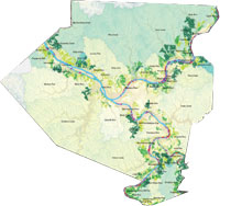 Ecology and Recovery - Allegheny County is the culmination of the 3 Rivers 2nd Nature Project, a five year inquiry directed by artists Tim Collins and Reiko
Goto. Using full page maps, photographs and charts, the report reveals extraordinary ecological opportunities in Allegheny County, providing a solid foundation for greening our collective future. The STUDIO for Creative Inquiry is grateful to the interdisciplinary team of artists, geologists, botanists, architects, planners, historians, regulatory experts, and Geographic Information Systems (GIS) specialists that participated in gathering the material for this report and to the Heinz Endowments for their support.
Forward
The idea that nature has value in an urban setting is just starting to take hold in Western Pennsylvania. Where nature needs sunlight and nutrients to thrive, new ideas need public discussion and a means of comparing what we know from the past to what is occurring in the present. It has been both our assignment and our great pleasure to consider the meaning, form and function of nature in Allegheny County, Pennsylvania. Principal funding for this effort was provided by the Heinz Endowments through a research grant paid to 3 Rivers Wet Weather Inc., and then redirected to the STUDIO for Creative Inquiry at Carnegie Mellon University. The STUDIO is a recognized leader in interdisciplinary research in the arts and sciences. STUDIO projects demand the social application of creative knowledge.
In this report, we examine, value and rank the remnant and recovering ecosystems that support the natural health of the rivers and streams of Allegheny County. To activate that knowledge, we analyze techniques for preserving, conserving and restoring these systems. While these terms are often used interchangeably, they also describe different stages and philosophies of ecosystem protection. Traditionally, the conservation movement put forth the ability and need for humans to manage the natural environment through scientific means. It believes in the importance of human management of the environment for human benefit and is predicated on a firm faith in human capacity to manage nature effectively. The conservationist goal is planned and rational use of natural systems for human benefit. Partly in reaction to the conservationist’s focus on management for human use and benefit, the preservation movement developed a philosophy of protecting natural areas for their own benefit, not necessarily for human use. Indeed, active human intervention was believed neither necessary nor advisable. The struggle to create national wilderness areas, which were to be pristine lands untouched (or nearly untouched) by human hands, is one illustration of the philosophy of this movement.
Restoration refers to the process of deliberately managing a site to establish an identified, native and historic ecosystem. The Society for Ecological Restoration (SER) defines restoration as “the process of assisting the recovery of an ecosystem that has been degraded, damaged, or destroyed.” SER’s description is informative: “Ecological restoration is an intentional activity that initiates or accelerates the recovery of an ecosystem with respect to its health, integrity and sustainability.” The restoration
process contemplates active management of a damaged ecosystem until it has recovered its historical development path. While it may not be possible to restore land to its exact historical condition, it should be possible in many cases to reestablish the direction and boundaries of historical development.
Allegheny County was once a gorgeous place to live. The hills were covered in rich, deep forests that framed good healthy rivers. In the last thirty years, with the downturn of industry, nature has started to reassert its beauty, its sense of health and well-being and its service to our community. In December 2005, the Pittsburgh City Council passed a steep slope zoning ordinance that reflects the work that you are about to read. 3 Rivers 2nd Nature project team members worked closely with Allegheny Land Trust and Perkins Eastman Architects on the Pittsburgh Steep Hillside Zoning study. Things really are changing; our leaders are awakening to the value and import of our natural living infrastructure. They are starting to pay attention to the environmental issues that are essential to our youth. They are beginning to understand the relationship between the environment and the economy, and its role as a keystone to our future.
Municipal boundaries are a legal-cultural product of historic land use, ownership and political interest. Typically, municipal boundaries are informed but not in any way constrained by landscape ecology, topography or hydrology. The fact that the City of Pittsburgh now encompasses land on the north side of the Allegheny River, the south
side of the Monongahela and the pie-slice between the rivers is a very good example.
None of this is a problem until society and its political interests begin to think about the zoning and regulation of riparian land (land along a river or stream). The management and oversight of natural ecosystems can be instigated by environmental benefits or environmental threats, the latter being particularly actionable on the basis of public safety. The former, primarily an aesthetic and emergent economic value, is more difficult to pursue due to the bias of the Pennsylvania courts. (See Cyril
Fox on legal strategies for preserving and conserving land, P. 91-102)
It is important to consider the relationship between population growth, steep hills and once wooded valleys, and urban stream flow. Development impacts both water quality and quantity. If you lived in the valleys and flood plains of Streets Run, Chartiers Creek, Girty’s Run or Pine Run, you would notice significant changes to stream flow in the last ten years as development patterns changed and growth occurred in the hills above these valleys. With each major flooding event, instead of offering money to people so they can move away from the floodplains, the politicians request support from the U.S. Army Corps of Engineers to defend homes
from floodwaters. Uncontrolled development, coupled with the blatant (Pennsylvania Department of Environmental Protection approved) intent to ignore downstream impact of upstream development decisions, means we will have a century or more of flooding ahead of us. We typically react to the flooding with expensive, concrete infrastructure instead of sensible low cost proactive planning and land use controls, based on what we all now know about upstream development and downstream flooding. Our current controls do not work.
It is effective to look at the large watershed of Chartiers Creek, which drains to the Ohio. Chartiers Creek is both a multi-state and multi-municipal watershed where upstream development adversely effects downstream communities that are close to the floodplain. The issue is not flood water—water is the effect. The issue is unrestrained development and its impact on hydrology and ecosystems, as well as the constraints of the political boundaries that we rely upon to manage development, public safety and the public good. Allegheny County sprawls outward from the City of Pittsburgh, with population density decreasing the further you get away from the city. It is in the north and the west that the region is seeing the most significant growth and development that is radically altering the forest cover and hydrological characteristics of the land, adding significant infrastructure costs and creating downstream flooding problems for the riverfront communities that are not benefiting from development in the hills.
According to the Western Pennsylvania Conservancy (1994), the natural communities
of the county are now in a state of growth and recovery. But what are the conditions of present growth and the scope of recovery? Are remnant natural forests and recovering ecosystems of Allegheny County of any value? According to the text The Terrestrial Ecoregions of North America, Allegheny County is located in Appalachian Mixed Mesophytic Forest ecoregion which harbors “the most diverse temperate forests in North America.” The Appalachian Mixed Mesophytic Forest Ecoregion has been identified as globally outstanding and requires immediate protection and restoration. It is clear that we have amazing potential for recovery and stabilization of the natural ecosystems of Allegheny County. The question is how do we begin to quantify their value and understand their relative health?
As this report demonstrates, there are many strategies available to conserve, preserve and restore riverfront and supporting lands. These strategies consist of a mix of public and private actions. No one strategy nor one single institution may be appropriate for all of the land along the four rivers, but combinations of strategies can greatly improve the ecological health of Allegheny County’s river oriented location. The next step is to find public agencies, interested private citizens and private organizations willing to pursue them with vigor. This report is intended to provide tools for developers and conservationists alike. There is a better way and we must find it together.
We return this report to the citizens, the activists, the visionaries and leaders of Allegheny County who are prepared to do the real work of change. Once ideas have taken hold and the thinking has shifted, there are decades of work ahead of us. With one hand to the earth and its waters, we must reach out with the other to all who can help. Organizations like the Allegheny Land Trust, Friends of the Riverfront, Pennsylvania Environmental Council, Penn Future and the Sierra Club have been staunch allies on this project. Our friends and colleagues have attended countless meetings and participated in on-the-water “river dialogues” with the explicit intent to support public discussion about change. Our future is green, our future is wet and our future is forecast by the choices we make every day.
