Home> Artists & Rivers> Method
Method
The Art and Ecology group in the STUDIO for Creative Inquiry based their work on ideals of applied research with the intent to enable a creative democratic dialogue about the aesthetic and material recovery of nature along the post-industrial waterfronts of Western Pennsylvania. The research team had strategic relationships with non-profit environmental groups and research contracts with scientists, historian, planners, designers and environmental attorneys who all contributed knowledge and expertise which could help define and delineate the shift from industrial land-use to post-industrial recovery.
The 3 Rivers 2nd Nature Project conducted integrative analysis and instrumental planning based upon rigorous field studies that began in the year 2000. The work effort focused upon partnerships to achieve interdisciplinary analysis, spatial mapping, and concept design within and among specific communities. The work culminated with an Allegheny County Ecological Recovery Plan and Water Quality Citizen Action Plans. Finally, an International Exhibition and Catalogue documented projects from around the world dealing with social and environmental change.
Goals
The 3R2N project sought to understand the green infrastructure that provides social, aesthetic, ecological and economic benefit to the Three Rivers Region. Specific questions were:
- What do we know about surface water quality and what does it mean in terms of current policy, regulation, and efforts to resolve sewer infrastructure failure?
- What do we know about the ecology of our riparian waterfront lands and what does this mean in terms of current land use planning and development?
To answer these questions, 3R2N spent four years studying these areas and developed an extensive geographically referenced database on each topic area in the process.
Objectives
- Conduct a green infrastructure analysis. Current water quality, ecology, hydrology, habitat values, and public access were compared to historic information and databases. Baseline studies were established where possible.
- Identify opportunities for ecological restoration. The land and water systems provide an unusual scope and breadth of opportunity for improvement. Techniques include land preservation and conservations as well as active ecosystem restoration, new land use zoning and policies and active pollutant regulation.
- Understand the history and the basis for cultural restoration. Cultural restoration is an integrative change in the way a community thinks about infrastructure and ecosystems - the relationships between humans, land and water.
- Conduct public dialogue about the values relative to the above points.
Project Scope
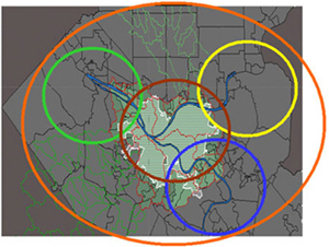
Three major rivers and 53 streams that flow into and through the edges of Allegheny County, Pennsylvania define the five-year project's scope. 3R2N examined water quality and urban riverbanks, the blue and green infrastructure of our recovering landscape. It began in year one (2000) at the center of Allegheny County, in what is known as the "Pittsburgh Pool." The project worked in the Monongahela Valley in Year 2, the Allegheny River Valley in Year 3, and the Ohio River in Year 4.
Project Need
The team did an exhaustive study of existing information prior to developing the protocol for the project. We found a void where information about water quality and riverbank edge conditions should exist. The Allegheny Conference report, "Investing in Clean Water," and the U.S. National Research Council report on wet weather problems in Western Pennsylvania confirm this understanding of the void in water quality data. The void in terrestrial data is less well documented, but equally poor (although the condition of current knowledge was not surprising in a region where broad leaf trees struggled for life under smoky skies no less than thirty years ago.)
